|
|
|
|
|
|
|
Getting Started | Czech Archives | Census Records | Military Records | Other Records | Contact Us |
|
|
These high-quality reproductions were published in the early 1990s by Geodézie Brno. Quantites are very limited. |
Landkartenreproduktionen
|
|
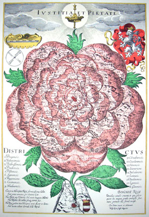
This beautiful map, which depicts Bohemia as a stylized rose - Bohemiae Rosa - was drawn by Christoph Vetter for Bohuslav Balbin's work of national history and geography Epitome historica Rerum Bohemicarum. Wolfgang Kilian, an engraver from Augsburg, made the copper engraving from a copy of Vetter´s drawing in 1668. The top of the map bears the motto of the Austrian emperor, Leopold I, "Iustitia et Pietate" (With Justice and Piety). The 18 administrative units of that period are listed on the lower part of the sheet. This included 14 regions, Prague, and three territories which had legal privileges (i.e. Loket, Cheb, and Hlad). The translation of the latin text is:"There grew a graceful Rose in the Bohemian woods, and an armoured lion standing guard next to her. That Rose had grown out of the blood of Mars, not of Venus. There was Rhodes as well as the jump and the country was created at once. Do not fear, lovely Rose! There comes the Austrian. May the gun of frightful shots cease under the stifled Rose! The Rose of Bohemia, bloody for all the centuries, where more than 80 battles were waged. She has been now drawn in this form for the first time." Prague is located at the center of the rose and Vienna is shown at the base. The leaves of the rose represent Moravia, Silesia, Meissen, Bavaria, and Austria. Map scale is cca 1:1,270,000 and the map measures 39.5 by 26.5 cm (15.5 by 10.5 inches). The sheet measures approximately 51 by 38 cm (20 by 15 inches). This four color, offset litho reproduction was published by Geodézie Brno in 1991. Price: $12 plus shipping. Item code: Bohemia 1677
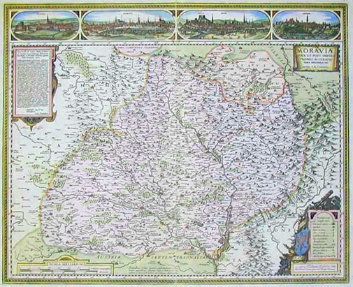
MORAVIAE NOVA ET POST OMNES PRIORES ACCURATISSIMA DELINEATIO. Jan Amos Komenský (1592-1670), the famous "Teacher of Nations" from Moravia, made immense contributions to the enlightenment of Europe in the 17th century. His map of Moravia was, without a doubt, the most important cartographic representation of Moravia ever produced. This map was still being published more than 150 years after it first appeared. The map was most likely published in 1624 by N. Visher's workshop in Amsterdam from A. Goose's large engraving. The size of the drawing is 54 by 44 cm; the scale according to the geographical net is 1:470,000, and according to the drawing of the contents of the map, about 1:520,000. While the Fabricius map depicts only about 350 localities in Moravia and Silesia, Komenský's map shows more than 530 localities. Not only did Komenský identify more localities, but their positions were much more accurate. In addition, Komenský's map depicted iron, gold & silver mines, hot springs, glass production centers, and vineyards. Drawings of Polna, Olomouc, Brno & Znojmo form a banner along the top of the map. Price: $15 plus shipping. Item code: Komenský 1624
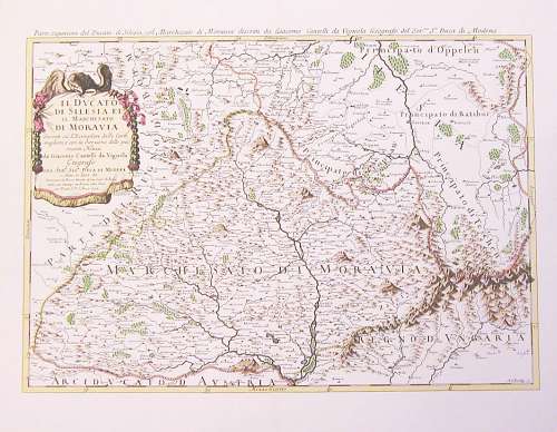
IL DUCATO DI SILESIA ET IL MARCHESATO DI MORAVIA descritti sù L'Esemplare delle Carte migliori, e con la direzione delle più recenti Notizie da Giacomo Cantelli da Vignola Geografo DEL SERMO. SIGR. DUCA DI MODENA e data in Luce da Domenico de Rossi Herede di Gio. Giaco. De Rossi dale sue Stampe in Roma alla Pace con Priuil S. P. l'Anno 1692. The largest engraving derived from Komensky's map of Moravia was made by A. Barbey for Giacomo Cantelli da Vignola (1649-1695), a Modena cartographer. The size of the drawing is 58 by 40.5 cm, the scale is about 1:530,000. The map is nearly an exact duplicate of Komensky's 1627 map. This map features a number of mountain names (e.g. Radhost, the Hostyn Hills). Price: $10 plus shipping. Item code: da Vignola 1692
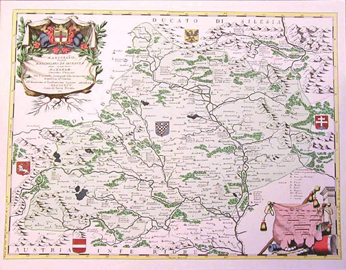
MARCOMANIA, hoggidi MARCHESATO DE MORAVIA detto uolgarmente MARNHEM, Descritta, e Dedicata Dal P. Coronelli, Cosmografo della Serenissima Republica di Venetia, All'Illustrissimo, et Eccellentissimo Signore ANDREA BRAGADIN, Sauio di Terra Ferma, etc. In 1692 another map of Moravia was published by a Franciscan friar, Vincento Maria Coronelli (1650-1718), a cosmographer of the Republic of Venice, manufacturer of globes, and the founder of the first geographic society in 1680. Although Komensky's map of Moravia was already known in his time, Coronelli used the obsolete map by Fabricius, with a lot of locations added by the publisher's unchained imagination. The size of the drawing is 61 by 46 cm, the scale is about 1:350 000. The map is a rarity in that it gives the names of localities in several different languages. For example, the Olomouc entry says in seven lines: Olmütz A., Olomoniec Pol., Holomaucz Mor., Olomutium L., Eburum, Episc: sotto l'Arciu di Praga gia Metropoli della Moravia. The Brno entry says: Brin, Brun A., Brno B., Bruna L., Brinnum L., Dichiatata Metrop. della Moravia 1642. Thus the names of towns are given in Latin - L., B. (Bohemian) which is incorrectly listed in the legend as Bulgarian, German - A., Polish - Pol., and, Moravian - M. Price: $10 plus shipping. Item code: Coronelli 1692
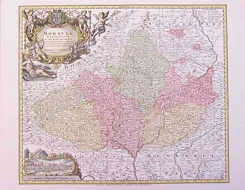
TABULA GENERALIS MARCHIONATUS MORAVIAE IN SEX CIRCULOS DIVISAE quos MANDATO CAESAREO accurate emensus hac mappa delineatos exhibet Ioh. Christoph. Müller S. C. M. Capitan. Editore Ioh. Bapt. Homanno Norimbergae. Cum Privilegio Sac. Caes. Maj. According to the plan elaborated by J. Müller, each of the six regions of Moravia was to be mapped independently and then these maps of the regions of Moravia were to be used to compile a map of the whole Margrave of Moravia. Field work began in the year 1708 and was finished in 1712. In 1714 Moravia was divided into newly established administrative regions. These new regions were different from those depicted in Müller's maps. Johann Baptist Homann (1663-1724) - engraver, map dealer, and a member of the Prussian Royal Academy of Sciences, published an atlas based on Müller's maps of the Moravian Estates. The atlas included a general map of Moravia and six special maps of Moravian regions. Maps of Znojmo and Jihlava regions were printed on one common sheet while those of Hradiste, Brno, Olomouc, and Prerov regions were printed on two sheets each and thus the atlas comprises 8 sheets in total. The scale of maps of the regions is identical with the scale of the map of the Moravian Estates but only according to the map representation. Price: $10 plus shipping. Item code: Müller 1728
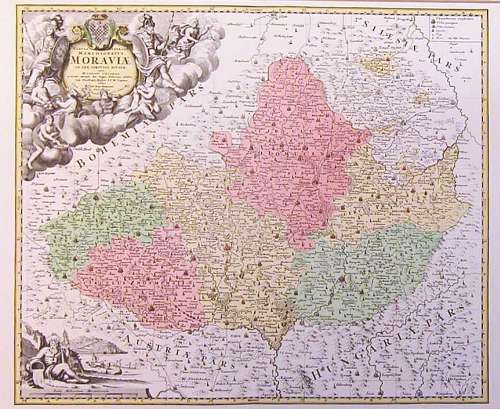
MORAVIA MARCHIONATUS IN SEX CIRCULOS DIVISUS JUXTA RECENTISSIMAM DIMENSIONEM ET ACCURATISSIMAS OBSERVATIONES AERI INCISUS ET VENUM EXPOSITUS A MATTH. SEUTTER, S. C. M. G. AUGUSTANO Based on Müller's map of the Moravian Estates, this map of Moravia was published by Matthew Seutter (1678-1757), draughtsman and engraver apprenticed with J. B. Homann in Nuremberg. He ran a cartographic office and publishing house in Augsburg where, later on, he worked with his son, Albrecht Charles Seutter, and T. C. Lotter. Dimensions of this map of Moravia are 54.5 by 46.5 cm and the bar-scale gives a scale of about 1:500,000 (according to the geographical net 1:685,000). It was a part of Seutter's compendium Atlas Novus and was probably printed around 1736. It has an orientational grid which indicates that an index of localities was probably provided with this map. A drawing of Brno based on G. Houfnagli's engraving of 1617 is depicted in the lower left corner. Price: $10 plus shipping. Item code: Seutter 1736
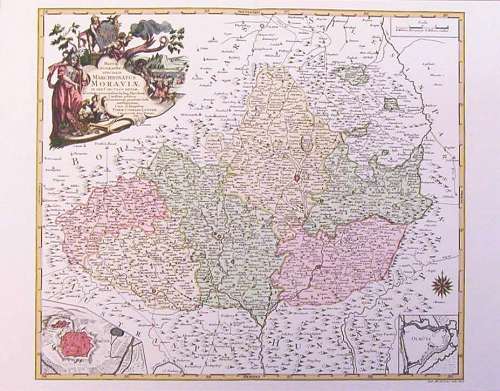
MAPPA GEOGRAPHICA SPECIALIS MARCHIONATUS MORAVIAE IN SEX CIRCULOS DIVISAE, ad notatis principaliorib9 huj9 Marchion: Cursibus publicis, ad meliorem praesentis belli intelligentiam. Cura et sumptibus TOBIAE CONRADI LOTTER, CHALCOGR. AUG. VINDEL. 1758. Another map of Moravia based on Müller's map of the Moravian Estates was published in the year 1758 by Tobias Conrad Lotter (1717-1777), engraver and publisher who apprenticed with D. Funk. This map of Moravia was engraved on copperplate by his eighteen-year-old son Matthias Albrecht Lotter (1741-1810). Thanks to the high quality of his engraving technique and the copperplate script, young Matthias contributed greatly to the prosperity of his father's firm. The dimensions of the map border are 54.5 by 47 cm and the scale is about 1:500,000 (by the geographic network 1:690,000). This map was most probably used for military purposes as is evident from the heading in the upper left corner. The principal regional centers are depicted as fortified towns and they're differentiated from other towns by capital letters. Depicted in the lower left corner of the map are the fortifications of Brno and, in the right corner, the fortifications of Olomouc. Price: $10 plus shipping. Item code: Lotter 1758
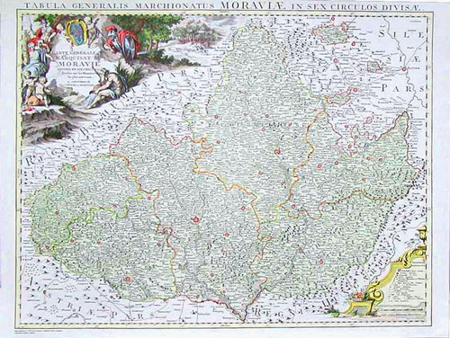
CARTE GENÉRALE DU MARQUISAT DE MORAVIE DIVISÉE EN SEX CERCLES dressée sur les memoires les plus nouveaux. A. AMSTERDAM Chez CÓVENS et MORTIER. An outstanding map of the Margrave of Moravia produced by Müller in 1790. Dimensions of the sheet: 70 by 53 cm (27.5" by 21"). Dimensions of the image: 64 by 49 cm (25" by 19.5"). Price: $15 plus shipping. Item code: Müller 1790
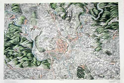
Brno in 1845 by Friedrich Mehl. This map shows Brno and surrounding communities circa 1845. The modern city of Brno has grown to encompass nearly all of the area shown on this map. The outlying communities are now neighborhoods within the city. Dimensions of the sheet: 51 by 73 cm (20" by 28.8"). Dimensions of the image: 45 by 67 cm (17.8" by 26.4"). This four color, offset litho reproduction was published by Geodézie Brno in 1990. Price: $15 plus shipping. Item code: Brno 1845
|
|
|
|
|
|
Getting Started | Czech Archives | Census Records | Military Records | Other Records | Links | Contact Us
|
|